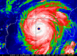
Hurricane Katrina was one of the most destructive tropical cyclones ever to hit the United States causing extensive damage to the coastal regions of Louisiana, Mississippi, and Alabama on August 29, 2005. By late morning of August 29 [1], the storm caused several sections of the levee system in New Orleans, Louisiana to collapse. Subsequent flooding over most of the city, a large part of which lies below sea level, resulted in widespread damage and many deaths, largely due to inadequate hurricane preparedness for New Orleans.
Later estimates placed the death toll in the thousands, and the damage is expected to surpass Hurricane Andrew as the costliest natural disaster in U.S. history (estimates run as high as $200 billion). Over a million people were displaced — a humanitarian crisis on a scale unseen in the U.S. since the Great Depression.
Federal disaster declarations blanketed 90,000 square miles (233,000 km²) of the United States, an area almost as large as the United Kingdom. The hurricane left an estimated five million people without power, and it may take up to two months for all power to be restored. On September 3, Homeland Security Secretary Michael Chertoff described the aftermath of Hurricane Katrina as "probably the worst catastrophe, or set of catastrophes" in the country's history, referring to the hurricane itself plus the flooding of New Orleans.
External links and sources
Disaster recovery
- KatrinaHousing.org: Offer housing to survivors, find housing if you are a survivor
- Coast Guard: Submit a report of Missing/Stranded Person
- Craigslist: Missing Persons, Aid, Volunteers, Temp Housing
- HurricaneHousing.org: Request or Offer Temporary Housing
- Gulf Coast News: Survivor Connector Database
- Hurricane Refugee Connect Site: Organized by Last Name
- Katrinahelp.info - Disaster recovery wiki.
Government
- Federal Emergency Management Agency
- Louisiana Office of Homeland Security and Emergency Preparedness
- Mississippi Emergency Management Agency
- NASA Hurricane Resource Page
- National Hurricane Center advisory archive on Katrina
- 500 Satellite images
Live streaming local coverage
The status of the following news feeds is subject to change.
- 22 minute video from WLBT 3 (NBC) news helicopter, surveying damage over coastal MS from Gulfport to Biloxi. August 30 2005, approx 4:00 p.m. Central. MMS link to video: mms://a1250.m.akastream.net/7/1250/12206/v001/worldnowwlbt.download.akamai.com/12206/WLBT_20050830112530.wmv
- Message board thread from WWLTV.com's forums detailing webstreaming statuses of various Gulf Coast TV and radio stations - this list includes local scanner coverage of police, USCG, and Amateur Radio communications in the affected areas.
- DirectNIC's live webcam of downtown's Central Business District, looking East from 650 Poydras towards Camp St. blog A map is at krioni.100free.com/interdictor.html
Modified from Wikipedia's article on Hurricane Katrina.
Note to users: The wiki is currently operating in safe mode. Editing is limited to users with certain privileges in order to deal with spam. You can create a new user account, and confirm your email ID in order to obtain ability to edit pages. Learn how to be an editor or sysop at WikiChristian.
- Sister projects: WikiMD.com Wellness Encyclopedia & Directory
- Sponsors: WikiChristian is supported by W8MD's medical weight loss and sleep centers.

