Difference between revisions of "Smith Bible Atlas"
Jump to navigation
Jump to search
Graham grove (talk | contribs) |
Graham grove (talk | contribs) |
||
| Line 14: | Line 14: | ||
<center><gallery> | <center><gallery> | ||
Image:Paul's Missionary Journeys Small.jpg|[[Apostle Paul|Paul's]] missionary journeys | Image:Paul's Missionary Journeys Small.jpg|[[Apostle Paul|Paul's]] missionary journeys | ||
| + | Image:Colossae.jpg|Map of the region around Colossae, Philadelphia, Ephesus, Laodicea, Rhodes, Patmos and Pisidian Antioch during the first century AD | ||
</gallery></center> | </gallery></center> | ||
Revision as of 04:54, 14 September 2007
Synopsis: The "Smith Bible Atlas" is book of maps (public domain) prepared by George Adam Smith. It's full title is: "Atlas of the Historical Geography of the Holy Land"
Contents
Related topics
Comments, Personal Articles, Studies and Sermons
Smith Bible Atlas (discussion) (For short comments and opinions)
Main article
The "Smith Bible Atlas" is book of maps (public domain) prepared by George Adam Smith. It's full title is: "Atlas of the Historical Geography of the Holy Land"
Maps
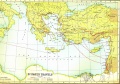
Paul's missionary journeys
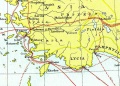
Map of the region around Colossae, Philadelphia, Ephesus, Laodicea, Rhodes, Patmos and Pisidian Antioch during the first century AD


Quotes
Links
Wikible - Category:Smith Bible Atlas
Return to Bible | Church History